

Try and find time to travel the winding roads, past the many caravans to Brean Down. 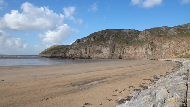 Once you are up on the summit, it is one of the most inspirational places in our area, and a great place to meditate or clear your mind.
The first historical evidence relates to 14000-10000 BC where at the end of The Ice Age, Bison, Mammoths, Reindeer, Giant Deer, Aurochs, Wolves, Arctic Foxes and Lemmings roamed. All of these have had fragments found in the layers of rock on the south
side of the Down near the beach. A carved Giant Deer Antler of about 10000BC was also found; confirming early hunters also visited the Down, and had probably done so for a long period of time, as evidence of early man being present in The Mendips exists back to nearly 500,000BC.
It was not until 3000BC that the Down became surrounded by water, as the climate warmed up, the ice retreated and the coastal plains became submerged. At this time a small farming community started, there is evidence of grazing stock and cultivation of the land. From 2000BC Bronze Age remains have been found at the Eastern End of the Down, beside the River Axe, this was probably the site of a hamlet with an early jetty. A Bronze Age Mound was built on the top of the Eastern Knoll. About 300BC a hill fort and defences were built consisting of a ditch across the breadth of The Down, iron had taken over as the main metal for tools, allowing quarrying of the limestone to take place for the defences, with tools very similar to the picks, shovels and wedges used today.

Within a few years of the Romans landing in Britain in AD43 they had organised the lead mining industry on the Mendips. A small port was built at nearby Uphill to export the minerals along with local produce, and imports from Roman and Phoenician Traders who were trading pottery, weapons, and fabrics for dairy produce, ale, mead, cider, wine, fruit, grain etc. This made Brean Down strategically important, and a Romano-British Temple was built on the Eastern Knoll near the Bronze Age Mound. This temple was a place only used by Acolytes and Hermits as a last stop on their journey from Glastonbury or Cheddar, praying for safe passage before setting sail, and for giving thanks for their safe crossing, the Temple being the first stopping place before traveling on to Glastonbury. It would have been a very cosmopolitan place with people from all over the Roman Empire, Scotland, Wales and Ireland. It is believed by some that Jesus would have stopped here, during 'The Lost Years' with his uncle Joseph of Arimathea, a metals and minerals dealer, as well as many famous Welsh and Irish Saints.
Although there is no actual proof, it is thought that around 8000BC in Megalithic Times the sea levels rose reaching Glastonbury, after the melt of the Ice Age. This allowed boats to sail to Glastonbury, also bringing many much earlier visitors from Wales, Ireland and the Mediterranean connecting the many Holy Sites along the Western Coast of Britain, Cornwall, The Gower, Caldey, Skomer, Bardsley, Mona on Anglesey, The Isle of Man, Arron, Iona, The Hebredies and Ireland. Brean Down became a stopping off point, as well as a place of shelter, as evidenced by the nearby stone circles and ancient remains, along with the other ancient remains predating Stonehenge, Avebury and other major sites, as at this time the rest of England was deeply forested.
It is hoped that one day it can be proved that an Atlantean Culture in the Predeluvian Period 12000 BC existed, where the Mid Atlantic Ridge exists today. A continent populated with an advanced culture, paralleled with Egypt, Sumeria, Mexico and Peru. With Ancient Britain connected by land to Ireland and the Continent, and the sea levels being over 500ft lower at this time, this may explain the Megalithic Landscape Alignments and Engineering, the principles of mathematics, the subtle energy-flows within nature and between Earth and the cosmos, and the many other mysteries of Avalon, which include Brean Down and the other Megalithic sites within Avalon. The Roman Temple fell into decline around AD370 to be replaced by a smaller building possibly a hermitage. This was maybe due to the introduction of Christianity by the Roman Emperor Augustine, and the building of an early Christian Church on top of the limestone Ridge at Uphill on the other side of the river (350AD), and a larger Saxon Church (700 AD) on the site of the existing church. By this time the trade had moved to Uphill Port across the other side of the river and prospered due to its direct road links via Bleadon and Banwell.
But in the 1840s a new harbour was proposed to provide safe anchorage for Mail Ships, and act as a port for crossing the Atlantic as the distance was advantageous in miles to Liverpool. Engineers prepared reports, drew up images of the scheme. The proposed harbour with a breakwater at the west end of the Down, and the docks at the east end, would have given adequate facilities for the largest vessels of the day at both high and low tide. The Brean Down Harbour Company was formed in 1861 with a working capital of £350,000. They entered into an agreement with the Bristol and Exeter Railway to provide a rail link extending the whole length of the Down to the main railway network. In 1864 the project commenced with the celebration of the laying of the foundation stone on Guy Fawkes Day, with over 200 local dignitaries, company officials and the town band sailing by paddle steamer to see Lady Eardley, Wilmot lowered the foundation stone into place. But, by the next morning the foundation stone had disappeared, it was later found off Steep Holm. While work continued on the breakwater, disagreements took place, and upon the death of the main contractor, the scheme was abandoned in 1868. Heavy storms destroyed much of the construction. There was another attempt to revive the scheme in 1887, with large scale coverage in the American Press, being sold as 'Five Days to Sail to England'. Although an agreement to link up with the Great Western Railway Company at Lympsham was made, the whole scheme failed again, never to be restarted.


In 1862 four acres at the end of Down were requisitioned to build a military fort, one of four in the Bristol Channel to combat the naval and military strength of the French. It was not completed until 1870 due to disagreements between the government and the contractor, seven Rifle Muzzle Loading Cannons from Woolwich were mounted in 1877, each weighing 7 tons, with a 30lb charge of gunpowder, able to fire a 112lb Palliser shot 1560ft per second. This could pierce armour at 1000 yards. The fort was approached over a dry moat from the Down through iron gates. The quarters could hold 50 men, positioned on the left, with the admin offices on the right. There were three main gun positions, 3 faced west, 3 North West, and one North. No shots were ever fired in action and life was very quiet ion the fort, with the exception of 5AM July 6th 1900 when the whole fort was rocked by a huge explosion, causing the death of Gunner Haines. He had fired his carbine down the shaft of the ventilator into No.3 magazine, beneath the western gun positions. This caused enormous damage, demolishing the outer wall and wreckage was thrown over 200 yards. It is still a mystery why he blew up the fort, but the fort was closed and the cannons hauled away by traction engines.
Between 1905 and 1939 the fort was a cafeacute;, but with the start of the 2nd World War it was re-armed with two 6 naval guns from Cardiff, and two searchlight batteries. A rail track was built for testing secret weapons, and a so called bomb was mounted on a six hundred weight trolley propelled at 200mph along the track by 12 powerful rockets. The aim being to propel the trolley at high speed into the buffers, the impact sending the bomb far out to sea, but the whole lot went - trolley, buffers and all went off into the Bristol Channel, then did a sharp right turn and returned inwards into a local farmers chicken run. After many years of neglect, the Victorian Barracks were renovated in the1980s and 1990s, and made safe for visitors to safely walk around the remains of the fort.
Brean Down is managed by the National Trust as a nature reserve and historical site, and is 1.5 miles in length. It stands 100 metres, or 320 ft above sea level on the summit of the western knoll. There are two ways up, the 150 steps, or the original tarmac pathway. With a pathway along the top ridge and the old fort road, the views are breathtaking. You can see Weston-Super-Mare, Worlebury Camp and the bay to the north, South Wales and the Breacon Beacons, Steep Holm and Flat Holm in front of you, the sands and the west coast of Somerset, with the Quantocks and Exmoor to your left, and then Behind you can see the Sacred Sights of Brent Knoll, Glastonbury Tor and the Mendips, Tower Head, Bleadon Hill and Uphill.
